 HOME
HOME 3D RENDERING
 3D SCANNING
 XR DEVELOPMENT
3D Virtual Tours for public sector and government
Capture and document government facilities, public infrastructure and civic spaces with Matterport 3D virtual tours. From asset reporting and compliance documentation to stakeholder briefings and public engagement, 3D Walkabout helps agencies and departments maintain accurate, shareable visual records of any site.
Federal Government
3D Walkabout provides federal agencies with a fast, accurate and cost-effective way to assess, document and manage their facilities. Government and defence sites can be captured and turned into a detailed, fully navigable digital twin within hours, giving teams deeper visibility across their buildings for better efficiency, collaboration and operational outcomes.
State and Local Governments
From schools and health facilities to council buildings and public infrastructure, state and local agencies rely on accurate, up-to-date records of their spaces. 3D Walkabout’s Matterport scans can be used across a facility’s full lifecycle, from design and construction through to ongoing asset management, emergency planning, wayfinding and smart city development.
The 3D Walkabout Advantage
Give your agency a smarter way to manage and communicate across sites. With accurate Matterport digital twins, teams, contractors and partner organisations can securely collaborate on any space without needing to be on location.

Enhance Public Safety
Public safety agencies can use Matterport 3D scans to create complete, accurate representations of incident scenes and facilities, improving collaboration, workflows and physical security for both staff and the communities they serve.
- Reduce time spent on scene and lower risk exposure
- Minimise bias and human error in documentation
- Run virtual training and collaborative walkthroughs
- Capture as-builts for pre-plans, code compliance and wayfinding
- Present compelling visual evidence for crime and fire scenes
- Meet certification and agency standards
Engage with Citizens and Community
Federal, state and local agencies can extend their physical presence with a digital one, making services, spaces and information more accessible to the communities they serve.
- Offer virtual access to landmarks, venues and historic sites around the clock
- Maintain continuity of operations during disruptions, adverse weather or emergencies
- Improve accessibility for visitors, people with disabilities and special needs communities


Improve Facility Management and Operations
Matterport digital twins give agencies critical building intelligence including measurements, dimensions and physical layout, reducing the cost of site surveying and as-built modelling by up to 80%.
- Integrate with agency systems including Maximo, SAP and Archibus via Matterport’s API/SDK
- Automate asset recognition and use tags to label equipment for repairs, maintenance and training
- Use 3D indoor mapping to support staff onboarding, wayfinding and site orientation
3D Matterport Tours for Public Sector and Government
Matterport 3D tours give government agencies and departments a clear, visual record of facilities, infrastructure and public spaces at every stage of their lifecycle. From initial condition assessments through to construction progress, fit-out and ongoing asset management, each scan creates a fully navigable digital twin that can be reviewed, shared and referenced at any time. For facility managers and project leads, this means better documentation, fewer unnecessary site visits, clearer communication across teams and contractors, and a reliable visual record if compliance questions or disputes arise.
By capturing spaces before walls are closed or works are completed, including structural elements, services, finishes and site conditions, Matterport tours help public sector teams reduce confusion, speed up decision-making and maintain a complete digital record of every asset from start to finish.
Actionable facility data for government operations.


Facility and space records
+Maintain accurate digital records of facilities, floor plans and operational spaces to help government and infrastructure teams:
- Reduce unnecessary site visits and travel
- Improve visibility across departments and contractors
- Support long-term space planning and utilisation reviews
Capital planning and project baselines
+Create reliable visual baselines before upgrades, refurbishments and infrastructure projects to improve:
- Budget forecasting and cost estimating
- Project coordination between stakeholders
- Contractor communication and planning accuracy
Operations and maintenance data
+Give maintenance and facilities teams visual access to building conditions, assets and operational areas to help:
- Support remote inspections and assessments
- Extend the lifespan of critical infrastructure assets
- Prioritise maintenance work and reduce downtime
We’re in your backyard!
We operate nationwide across Australia with the biggest network of operators in the country.
Just give us a call on 1300 00 3392 or contact us here for an instant quote and to get booked in.

3D VIRTUAL TOURS <500 SQM $500 NATIONWIDE
BOOK NOWBenefits of using 3D virtual tours for Public Sector and Government
Support compliance and audit requirements. Maintain a time-stamped, fully navigable visual record of government facilities and public assets that meets documentation standards and holds up under scrutiny.
Improve cross-agency collaboration. Give teams, departments and external contractors a shared view of any site without coordinating physical access or travel.
Enhance public transparency and engagement. Make government facilities, sites and civic spaces virtually accessible to the public around the clock, without the overhead of physical tours or open days.
Strengthen asset and facilities management. Capture accurate spatial data across your entire property portfolio to support maintenance planning, condition reporting and lifecycle management.
Document public infrastructure at every stage. Record construction progress, fit-out and site conditions from the ground up, creating a permanent reference for project teams and stakeholders.
Reduce the need for physical access. Give inspectors, auditors and project teams a fully navigable view of any site without coordinating on-site visits or disrupting operations.
Speed up approvals and decision-making. Use a 3D record to clarify site conditions, reduce back-and-forth across departments and help teams reach decisions faster.
Support handover and defect documentation. Provide a detailed visual record of completed works, finishes, layouts and key site details at the point of practical completion or asset transfer.
Manage multiple sites and projects from one place. Give agencies and project leads a practical way to monitor progress across several locations without relying solely on photos, reports or repeated site visits.
Build community and stakeholder confidence. Demonstrate that facilities and infrastructure are being professionally documented, maintained and managed with full transparency.
How are Matterport 3D tours currently being used by government and public sector agencies in Australia?
Matterport 3D tours are being used by government agencies and public sector organisations to document facilities, support asset management and improve collaboration across sites and departments. Rather than relying on site photos, written reports or physical inspections, a Matterport scan gives project teams, facility managers and stakeholders a way to virtually walk through any property at any stage of its lifecycle, from condition assessments and construction progress through to compliance documentation and asset handover.
For facility managers, it means maintaining an accurate visual record of government properties without repeated site visits, with structural elements, services and finishes captured before works are concealed. For project leads and planners, it provides a practical way to monitor progress remotely, verify works against design intent and keep departments informed without coordinating physical access every time.
A powerful suite of features.

Security
Built for government-level security and compliance requirements.

Partnerships
Put all your data in one place with partner integrations.

Integrations
Integrate building files directly to construction and project management projects.

Tools
Securely collaborate, plan, and share with agencies, vendors, or response partners.

Professional 3D capture with minimal disruption.
3D Walkabout provides trained, experienced scanning professionals to capture government facilities accurately and efficiently.
Our team is available for secure, occupied and hard-to-access environments and can be scheduled to work around agency policies, operational hours and site requirements.
Book Your Matterport 3D Scan
Get pricing, timelines, and expert advice for your Matterport project.
From immersive 3D virtual tours to fully detailed digital twins, we deliver fast, accurate Matterport scans using the latest Pro3 technology. Fill out the form to get our Matterport pricing guide and see exactly how your project will work — from capture through to final delivery. Or call us on 1300 00 3392 to get started today.
Our Recent Projects
-
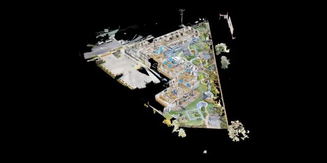 Childcare 3D Virtual Tour | 21 McIntyre St Matterport See how a full 2400 sqm childcare site was captured with a high-quality 3D virtual tour
 -
 AMS Constructions TerryWhite Chemmart Beenleigh 3D Tour Discover how AMS Constructions delivered fast-turnaround Matterport 3D scans for TerryWhite Chemmart Beenleigh, managing multiple sites, tight schedules,
 -
 Campbell Architecture | Matterport Scan of Claremont Property 3D Walkabout captured a Matterport scan of a Claremont home, giving Campbell Architecture a digital twin they
 -
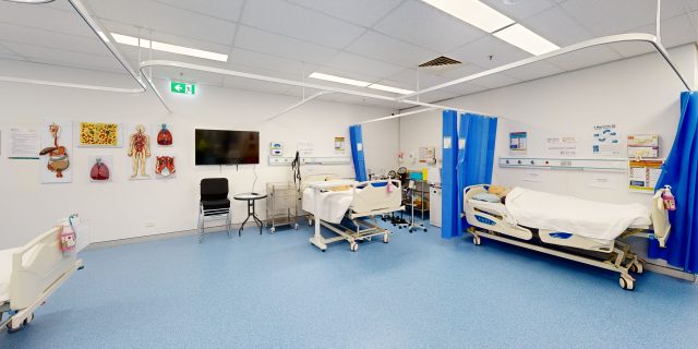 Health Careers International | Virtual Tour of IHNA Brisbane Campus 3D Walkabout captured IHNA’s Brisbane campus using Matterport, delivering a clean, self-guided virtual tour with
 -
 Varsity Cannington Virtual Tour | Matterport for Hospitality Venues We delivered a detailed Matterport tour of Signature Hospitality’s Varsity Cannington, showcasing key feature areas and
 -
 TSA Riley | Matterport Virtual Tour of Aged Care Facilities 3D Walkabout captured fully operational aged care buildings for TSA Riley using Matterport, creating a
Frequently Asked Questions
What facility management challenges can Matterport 3D tours help government agencies solve?
3D Walkabout’s Matterport scans help government teams document, manage and plan facilities using accurate digital twins that support asset tracking, maintenance workflows and space planning.
How dimensionally accurate are Matterport 3D scans of government facilities?
Scans produce highly accurate digital twins meeting LOD 200 specifications, providing a reliable baseline for as-built measurements, spatial planning and facility documentation.
Which security and compliance standards does Matterport support for government scanning?
Matterport supports SOC 2 Type II, SAML 2.0 SSO, FedRAMP certification requirements and privacy frameworks including GDPR and CCPA, available upon request for qualifying agencies.
Can government agencies request local or country-specific data residency?
Yes. Agencies with specific data residency or hosting requirements can contact 3D Walkabout to align deployment and contractual terms with agency policies.
Can we export point clouds and BIM-ready files from Matterport government scans?
Yes. Available exports include OBJ files, point clouds, floor plans, E57 files, BIM outputs in RVT and IFC formats, and CAD formats including DWG and XYZ.
Can 3D Walkabout manage the scanning of our government facilities directly?
Yes. 3D Walkabout handles the full capture process on your behalf. No hardware is required and completed digital twins are typically delivered within 48 hours.
How much does scanning a government facility with 3D Walkabout typically cost?
Cost depends on facility size, complexity, capture method and selected deliverables. Contact 3D Walkabout for a tailored quote based on your specific project requirements.
Does Matterport single sign-on integrate with existing government identity systems?
Yes. Matterport supports SAML 2.0 SSO, allowing agencies to integrate with existing identity providers for centralised, secure user access and authentication.
What onboarding, training and support does 3D Walkabout provide for government agencies?
3D Walkabout offers onboarding assistance, technical documentation, customer success management and API and SDK resources to help agencies implement and scale their scanning programs.
Can Matterport digital twins support emergency planning and wayfinding across facilities?
Yes. Digital twins can support emergency pre-planning, staff wayfinding, simulated training environments and broader smart infrastructure initiatives across government sites.