Multi-Site 3D Scanning Services
Capture Building Portfolios and Asset Networks Across Multiple Locations
Multi-Site Laser Scanning
Many organisations manage large portfolios of buildings, infrastructure assets or industrial facilities located across multiple sites. Accurately documenting these environments can be extremely challenging using traditional surveying methods, particularly when sites are spread across different cities or regions. Multi-site 3D scanning provides an efficient way to capture detailed spatial data across entire asset portfolios. Using advanced LiDAR scanning technology, multiple locations can be documented and converted into precise digital datasets.
3D Walkabout provides professional multi-site 3D scanning services across Australia, helping organisations capture spatial data for property portfolios, infrastructure networks and industrial facilities located across multiple sites. By combining high-precision laser scanning with coordinated data processing workflows, our team can capture consistent and reliable data from numerous locations and deliver unified digital datasets. These datasets can then be used to support engineering design, renovation planning, asset management and digital twin creation across entire property portfolios. For organisations managing large asset networks, multi-site scanning provides a scalable solution for capturing accurate spatial information.
What is Multi-Site 3D Scanning
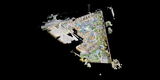
Multi-site 3D scanning refers to the process of capturing spatial data from multiple locations using LiDAR scanning technology.
Each site is scanned using high-precision laser scanners which capture millions of spatial measurements representing the geometry of the environment. These measurements form detailed point cloud datasets. When scanning multiple sites, the captured datasets are processed using consistent workflows to ensure that all data aligns with the same coordinate systems and quality standards.
This allows organisations to build accurate digital records of their entire building portfolio or asset network.
Multi-site scanning is commonly used by organisations managing:
- Retail store networks
- Property portfolios
- Infrastructure assets
- Industrial facilities
- Government building portfolios
Once captured, the datasets can be converted into CAD drawings, BIM models or digital twin systems that support long-term asset management.

Benefits of Laser Scanning
Consistent Data Across Sites
All locations are captured using standardised workflows.
Efficient Portfolio Documentation
Large asset portfolios can be documented quickly.
Improved Asset Management
Accurate spatial data supports long-term facility planning.
Reduced Survey Costs
Laser scanning reduces time spent capturing site measurements.
Supports Digital Twin Programs
Point cloud datasets can support enterprise digital twin initiatives.
Scalable Data Capture
Scanning workflows can be scaled to cover hundreds of locations.
Industrial Laser Scanning Typical Applications

Retail Store Networks
Retail brands can document store layouts across multiple locations.

Commercial Property Portfolios
Property owners can capture spatial data across entire building portfolios.

Infrastructure Networks
Transport and utilities infrastructure can be documented across regions.

Government Facilities
Government agencies can capture building portfolios for asset management.

Industrial Asset Networks
Manufacturing companies can document multiple facilities.

Facilities Management
Organisations can maintain accurate digital documentation of their assets.
Industrial Laser Scanning Documentation Workflow
Portfolio Planning
Identify the sites to be captured and determine scanning requirements.
Site Laser Scanning
Capture spatial data across each location using LiDAR scanners.
Data Registration
Combine scans into unified datasets.
Data Processing
Prepare point cloud datasets for modelling.
Data Delivery
Provide datasets ready for CAD, BIM or digital twin workflows.
Industrial Laser Scanning Deliverables
Registered point cloud datasets
CAD drawings
BIM models
Digital twin datasets
Facility documentation
Software & Technology


Start Your 3D Scanning Project
Speak with our team or request our 3D Scanning Information Pack & Price Guide.
Whether you’re planning a reality capture project, need accurate point clouds, BIM modelling, or are exploring digital twin solutions, our team can help. Complete the form below and we’ll send you our 3D Scanning Information Pack & Price Guide, along with details on how our scanning process works and typical project costs. If you’d prefer to talk it through, feel free to call us on 1300 00 3392
Our Recent Projects
-
 Childcare 3D Virtual Tour | 21 McIntyre St Matterport See how a full 2400 sqm childcare site was captured with a high-quality 3D virtual tour
 -
 AMS Constructions TerryWhite Chemmart Beenleigh 3D Tour Discover how AMS Constructions delivered fast-turnaround Matterport 3D scans for TerryWhite Chemmart Beenleigh, managing multiple sites, tight schedules,
 -
 Campbell Architecture | Matterport Scan of Claremont Property 3D Walkabout captured a Matterport scan of a Claremont home, giving Campbell Architecture a digital twin they
 -
 Health Careers International | Virtual Tour of IHNA Brisbane Campus 3D Walkabout captured IHNA’s Brisbane campus using Matterport, delivering a clean, self-guided virtual tour with
 -
 Varsity Cannington Virtual Tour | Matterport for Hospitality Venues We delivered a detailed Matterport tour of Signature Hospitality’s Varsity Cannington, showcasing key feature areas and
 -
 TSA Riley | Matterport Virtual Tour of Aged Care Facilities 3D Walkabout captured fully operational aged care buildings for TSA Riley using Matterport, creating a
Frequently Asked Questions
What is multi-site laser scanning?
Multi-site scanning captures spatial data from multiple locations across a portfolio of buildings or assets.
How accurate is scanning across multiple sites?
Each site can be captured with millimetre-level accuracy.
How many sites can be scanned?
Scanning programs can scale from a few sites to hundreds of locations.
What deliverables are produced?
Point clouds, CAD drawings and BIM models are typically delivered.
Can multi-site scanning support digital twin programs?
Yes. Many organisations use scanning to build digital twin models of their assets.
Do you provide scanning across Australia?
Yes. 3D Walkabout operates across Australia.
How long does a multi-site scanning project take?
Timeframes depend on the number of sites and their complexity.